Sixty in 2013: Point Reyes National Seashore, CA – Coast Trail to Alamere Falls
Leave a commentJanuary 28, 2013 by Deborah W. Trotter

If you’re seeking variety in your hiking experience, you will find it in abundance on the Coast Trail that runs for miles along the southwestern edge of Point Reyes National Seashore. From the south, the trail begins at Palomarin, just above Palomarin Beach and a few miles north of the funky town of Bolinas.
Last Sunday was a beautiful day in the San Francisco Bay Area, clear at the coast and warm, up to 70 degrees by early afternoon on the trail. The Coast Trail is new territory for my husband and me as we set out at 10:00 a.m. for Alamere Falls, 4.2 miles away.
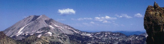
We begin the hike in a eucalyptus forest, but soon the trail heads out to the cliff tops above the ocean.

Coast Trail, Point Reyes National Seashore

Farallon Islands, 30 miles west of the Golden Gate
Suddenly there are no more tall trees, only ground cover, plants clinging to the coastal soil, and views in every direction. The Farallon Islands are visible to the southwest, and to the northwest we see Point Reyes itself, where the lighthouse is, across the blueness of Drakes Bay. Not a wisp of fog anywhere!
The trail hugs and climbs the cliffs for a distance,

Looking northwest from the Coast Trail
and then turns inland again, and we make our way through evergreens, ferns and lushness that is completely surprising just steps from the comparatively barren coastal highlands.

Coast Trail
We cross a couple of creeks on wooden bridges, see some wildflowers (an iris in the cool shade of a creek bed
and one brave California poppy claiming the middle of the rough trail), and keep reminding ourselves that the Pacific Ocean is right nearby, though out of sight, its breakers out of earshot.
What is underfoot changes as we hike, from coastal soil to rock to dry dirt to rock-strewn ruts and even stretches of trail softly cushioned with layers of pine needles. Although it has been a few weeks since much rain has fallen in northern California, parts of the trail are still muddy, leading me to believe that there may be times in winter when the trail is impassable.
Just over two miles from the trailhead, we pass several ponds, ducks happy on one, another hosting healthy lily pads. Soon we look down on Bass Lake

Bass Lake, Point Reyes National Seashore
and about a mile farther along the trail, Pelican Lake,

Pelican Lake, Point Reyes National Seashore
both blue and sun-dappled. The trail has gone steadily downhill for the past mile or so, and not far past Pelican Lake we come to a turnoff to Alamere Falls: four tenths of a mile on an “unmaintained trail.” At that point we can see the coast again and hear water, either the surf or a waterfall, and we aren’t going to stop now!

Looking northwest, Point Reyes and Drakes Bay in the distance
The unmaintained trail is narrow, crowded from either side and above by undergrowth. When we get out into the open again, the trail becomes quite steep and rutted. But we push on, downward. Having no familiarity with Alamere Falls before deciding to hike there, we do not know what to expect. So when we get close enough to see the Falls, we are more than thrilled with our choice of destination. Here’s what was waiting for us, fully revealed after a bit of a hairy scramble (using hands and feet and butt!) down the last 30 feet of the “trail” through eroding fissures in the coastal soil.

Upper falls

Upper middle falls

Lower middle falls
And then, the final drop onto the beach below!

Alamere Falls, the final drop
Four whitewater cascades, lilting liquid sculpture, cold, clear H2O, tumbling down the cliffside and into the ocean, now ready to start the water cycle anew. Nature doesn’t get much better than this.
For the record, this hike puts me 8.4 miles closer to achieving my 2013 goal of hiking 60 miles of National Park trails new to me (see my Happy New Year post on 12/31/12). Yay!
